All Departments
Top Sellers

|
Top Spot N208 Map- Middle Key Long Key To Boca Chica Key LORAN-C & GPS | ★★★★☆ | 86 | $21.95 | B0007RKZKG |

|
Blue Sea Systems Black 60 Label Set | $9.96 | B000HOTID4 | ||

|
RiverMaps Colorado River in The Grand Canyon Map - 4th E | $39.95 | B002BZT46S | ||

|
Great Lakes Salmon and Trout Ident-I-Card - Freshwater Fish Identification Card | $1.79 | B008ACUFX2 | ||

|
Fish Ident-I-Cards - Set of 9 Freshwater Fish Identification Cards | $12.95 | B008ACWN8C | ||

|
Humminbird Electronic Chart AutoChart Pro | $249.99 | B00JKT73X4 | ||

|
Humminbird Lakemaster Plus Wisconsin Contour Digital GPS Map, Black | $149.99 | B00MVYU7RO | ||

|
Humminbird 600033-1 AutoChart Zero Line North America Map SD Card | ★★★★☆ | 92 | $78.03 | B00S3TU2F8 |

|
Elite-7 Ti - 7-inch Fish Finder with TotalScan Transducer and C-MAP PRO Map Card | $1719.10 | B016QVXQMU | ||

|
Lowrance Hook-5 Sonar/GPS Mid/High/Downscan Fishfinder | $858.48 | B016QVY4OY |
New Releases
|
|
B01C4PK8B4 | B01C4PK8B4 | |||
|
|
B01C4PNDSY | B01C4PNDSY | |||
|
|
B01C4POLHG | B01C4POLHG | |||
|
|
B01C4PQJRG | B01C4PQJRG | |||

|
Metedeconk Neck to Surf City, NJ - Laminated Nautical Navigation & Fishing Chart by Captain Segull's Nautical Sportfishing Charts | Chart # MBB358 | $17.95 | B01CAVY74G | ||

|
Surf City to Brigantine Inlet, NJ - Laminated Nautical Navigation & Fishing Chart by Captain Segull's Nautical Sportfishing Charts | Chart # LEG359 | $17.95 | B01CAVY7UK | ||
|
|
B01DAN5PV2 | B01DAN5PV2 | |||
|
|
B01DAN5RPG | B01DAN5RPG |
Most Gifted

|
Sportsman's Connection Northwestern Michigan Fishing Map Guide | $24.95 | B000GEUZ9Q | ||

|
Western Adirondacks New York Fishing Map Guide | $36.98 | B000GEWVVG | ||
|
|
Blue Sea Systems Black 60 Label Set | $9.96 | B000HOTID4 | ||
|
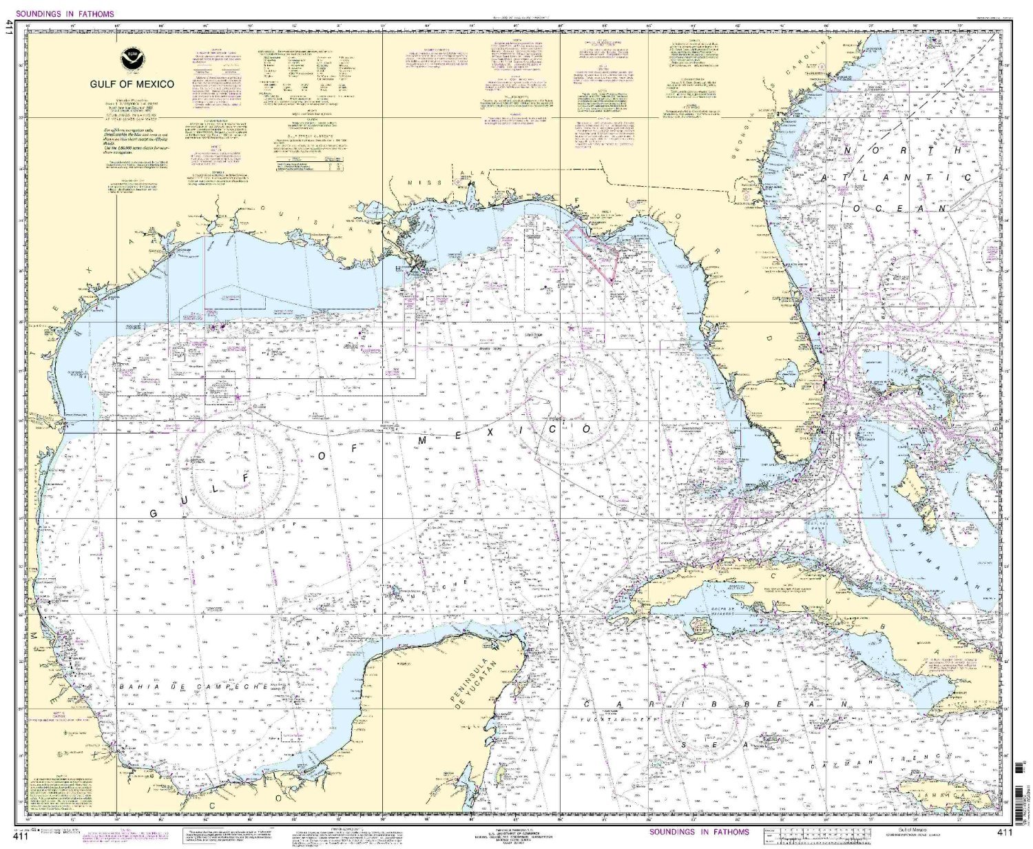
NOAA Chart 411: Gulf of Mexico | ★★★★☆ | 11 | $18.75 | B000HOUKZO |
|
|
Fish Ident-I-Cards - Set of 9 Freshwater Fish Identification Cards | $12.95 | B008ACWN8C | ||

|
Navionics+ Global Regions Marine and Lake Charts on SD/MSD | $249.00 | B00EUI3LY0 | ||

|
Paradise Cay Publications NOAA Chart 14935: White Lake 21.00 x 24.84 (SMALL FORMAT WATERPROOF) | $12.95 | B00M9PETSI | ||

|
Paradise Cay Publications NGA Chart 11: North Atlantic Ocean - Northern Part (TRADITIONAL PAPER) 30.5 x 44.5 | $24.95 | B00ORQM06K | ||

|
Lowrance Hook-4 Sonar/GPS Mid/High/Downscan Navionics+ Fishfinder | $707.86 | B016QVY4LC |